by John Thompson, Imogen Bellwood-Howard, Gebrehaweria Gebregziabher, Mohammad Shamsudduha, Richard Taylor, Devotha Kilave, Andrew Tarimo and Japhet Kashaigili
Groundwater is likely to become more important as a livelihood resource in Sub-Saharan Africa, as climatic change alters the reliability of rainfall and surface water flows. More than four years ago, an international group of collaborators embarked on a comparative study of ‘Groundwater Futures in Sub-Saharan Africa’. The Grofutures project focuses on three ‘basin observatories’: the Great Ruaha in Tanzania, the Upper Awash in Ethiopia, and the Iullummeden in Niger and Nigeria.
The ultimate aim of the project is to generate new evidence and relevant policy insights to open up new pathways towards more sustainable and ‘pro-poor’ groundwater futures in the wider regions around these basins. A key aim to achieving this has been to identify a range of existing, emerging and potential ‘groundwater development pathways’ in each basin. This work linked interdisciplinary, multi-scale research with a deliberative, multi-stakeholder engagement process to inform groundwater planning processes in the basins.
Identifying and characterising groundwater development pathways
Groundwater is used by women and men for irrigation as well as domestic, livestock rearing and industrial purposes, at a range of scales. GroFutures aims to ensure decisions regarding the management of these uses are based on a combination of understanding people’s needs and rigorous modelling of aquifer dynamics.
To achieve this, attempts were made to co-locate physical infrastructure for assessing groundwater recharge and storage, such as piezometer arrays, soil-moisture probes and rain gauges, with key stakeholder communities where the social science was conducted, using household surveys, rapid rural appraisals and well inventories (See Figure 1).
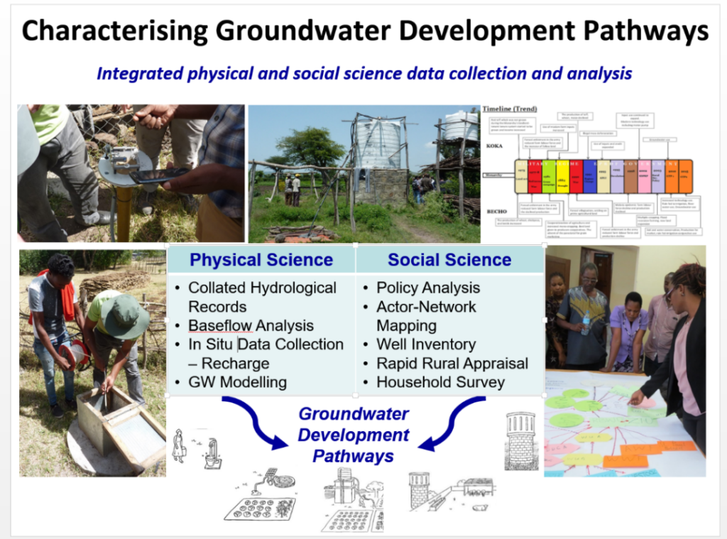
Six groundwater development pathways were conceptualised by the GroFutures Social Science Team during the course of the research. These pathways describe ‘stylised’ ways of using groundwater, and represent broader trends found across the three basin observatories. Each is characterised in terms of:
- socio-economic functions
- physical dimensions
- stage of development
- technology
- ownership, management and governance arrangement
- legal aspects of land and water access
- alignment with national and continental policy
- (importantly) its implications for poor water users – a key consideration of the project.
The six pathways were conceptualised in such a way as to be relevant across and even beyond the study context. This meant that connections to continental policy and development trends were considered. Also, each pathway was relevant to different extents in each basin. A pathway focused on commercial livestock management, for example, is not yet evident in our East African study basins.
‘Stress testing’
To analyse the longer-term sustainability of groundwater in each basin, the GroFutures Physical Science Team ‘stress tested’ or quantified the impacts of the groundwater development pathways, together with the impacts of climate and land-use change, on groundwater recharge and storage in each basin. The team employed a groundwater flow model using MODFLOW-2005, via the open-source, GIS-based interface (QGIS) that has been developed as part of the newly available FREEWAT platform under a HORIZON 2020 project. The team assessed the hydraulic impacts of pumping under a range of boundary conditions, including variable recharge, over different time scales. These impacts were represented in a set of maps for selected sub-basins. A simplified sketch was used alongside the maps to represent each pathway to basin stakeholders.
A key assumption is that these pathways may co-exist over time and meet the needs of different users. However, there may be cases where there are serious trade-offs between them, leading to positive and negative impacts for different water users and for the environment.
Summarising the six pathways
The summaries of the six pathways and their hydrological impacts for the Great Ruaha and Upper Awash Basins are outlined below. The maps below show the arrangement of wells modelled for each pathway in the Upper Awash, with each well extracting specified volumes at specified depths. The decline in groundwater level after five years of such pumping is also shown. The first five pathways affect the shallow aquifer, while the large-scale commercial agriculture pathway influences the deeper Upper Basaltic Aquifer.
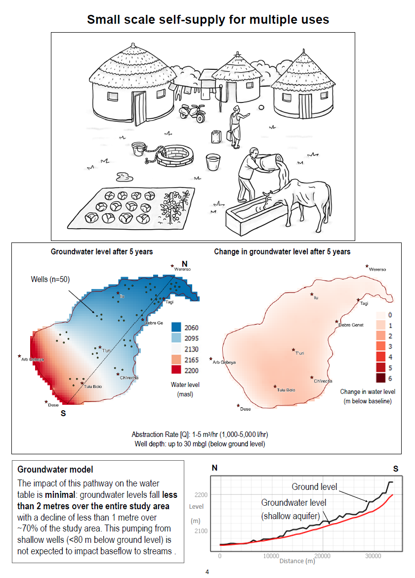
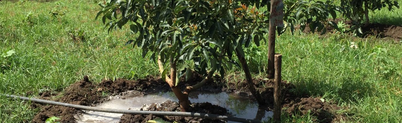
Pathway 1: Small-scale, self-supply for multiple uses
This pathway is evident now in both Tanzania and Ethiopia.
The impact of this pathway on the water table is minimal: groundwater levels fall less than 2 metres over the entire study area in both Tanzania and Ethiopia.
This pumping is not expected to impact the area covered by wetlands or their operation, nor the baseflow to streams.
Pathway 2: Small-scale private supply for smallholder intensified agriculture
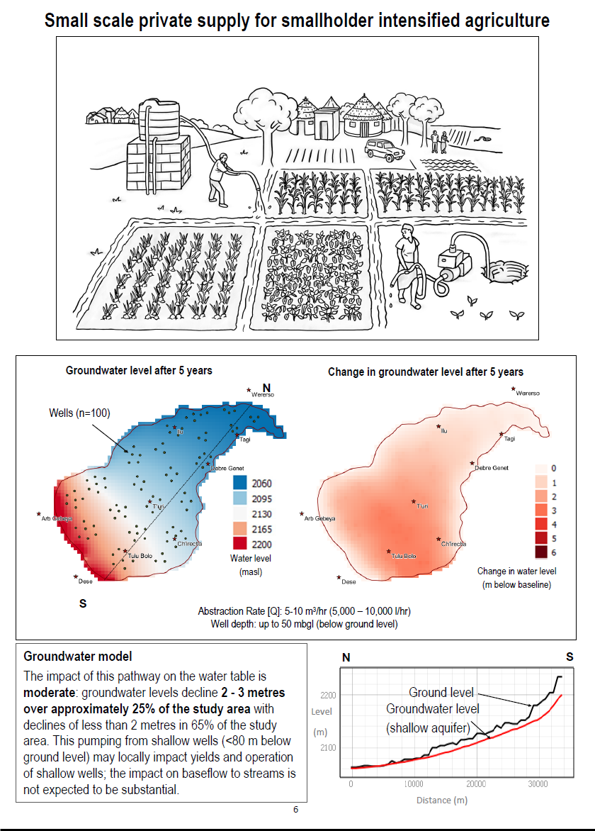
This pathway is not evident in Tanzania yet, although it is promoted in policy, but is emerging in Ethiopia.
The impact of this pathway on the water table is moderate: groundwater levels decline as much as 4 metres over approximately 40 per cent of the study area in Tanzania. In Ethiopia, the levels of decline are 2 to 3 metres over approximately 25 percent of the study area.
This pumping may impact the local operation of shallow wells. The impact on wetlands and baseflow to streams is not expected to be substantial.
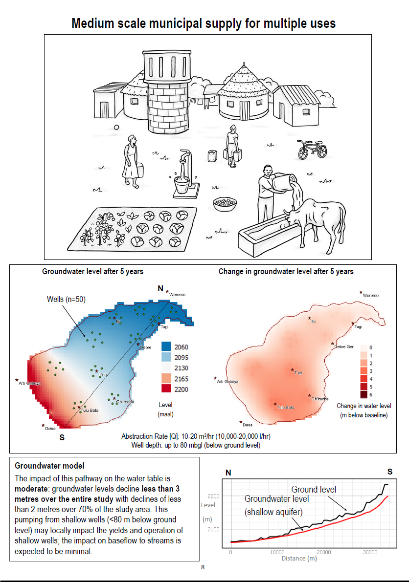
Pathway 3: Medium-scale municipal supply for multiple uses
This pathway is evident now in both Tanzania and Ethiopia.
The impact of this pathway on the water table is moderate. Groundwater levels decline less than 3 metres over the entire study in Tanzania and Ethiopia.
This pumping may locally impact the yields and operation of shallow wells. The impact on wetlands and baseflow to streams is expected to be minimal.
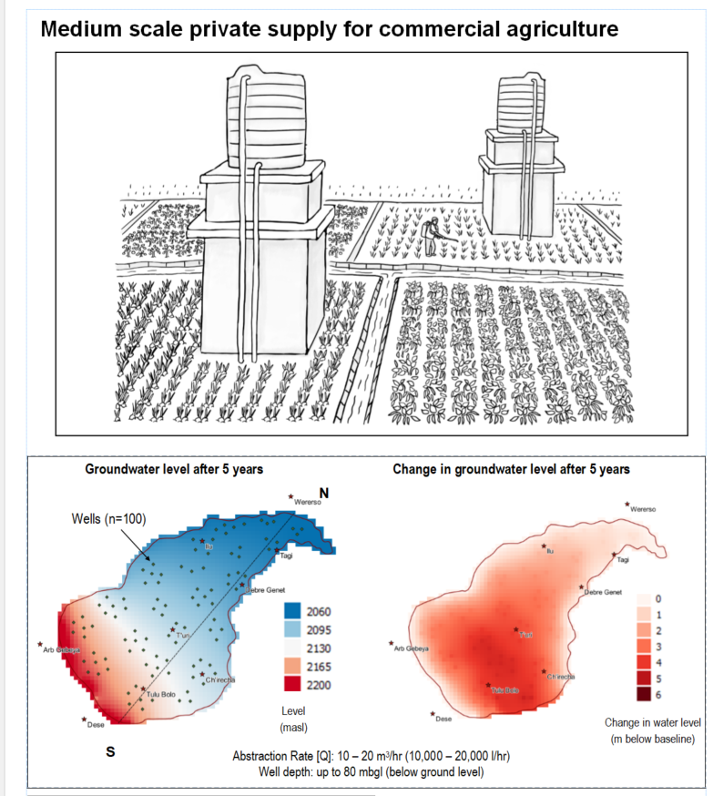
Pathway 4: Medium-scale private supply for commercial agriculture
This pathway is evident in Ethiopia though not in Tanzania.
The impact of this pathway on the water table is moderate to substantial. Groundwater levels fall up to 4 metres in approximately 40 per cent of the study area in Tanzania, and 3 to 5 metres over approximately 28 per cent of the study area in Ethiopia.
This pumping is expected to impact yields and operation of some shallow wells as well as baseflow to stream. The impact on wetland extent or operation is expected to be minimal.
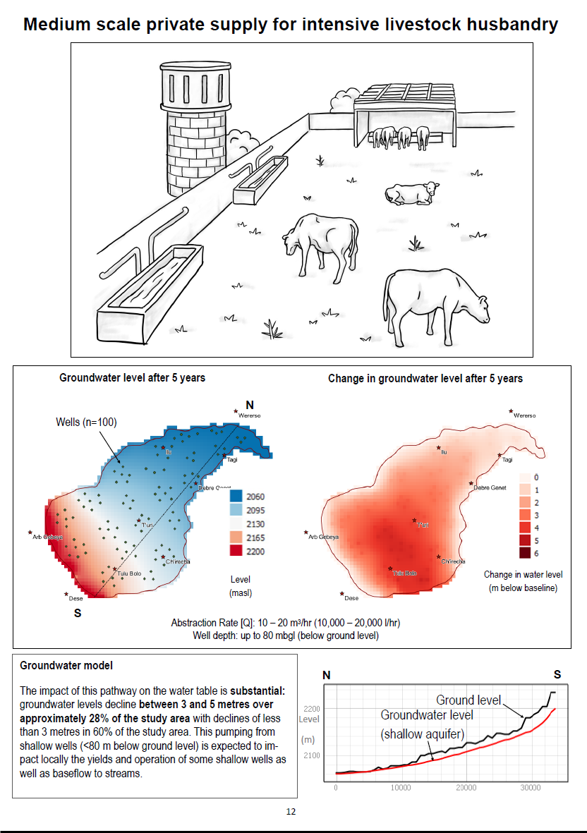
Pathway 5: Medium-scale private supply for livestock husbandry
This pathway is not yet evident in Tanzania or Ethiopia but is suggested in some policy approaches.
The impact of this pathway on the water table is moderate to substantial. Groundwater levels fall as much as 4 metres in approximately 40 per cent of the study area in Tanzania, and 3 to 5 metres over approximately 28 per cent of the study area in Ethiopia.
This pumping is expected to impact yields and operation of some shallow wells as well as baseflow to stream. The impact on wetland extent or operation is expected to be minimal.
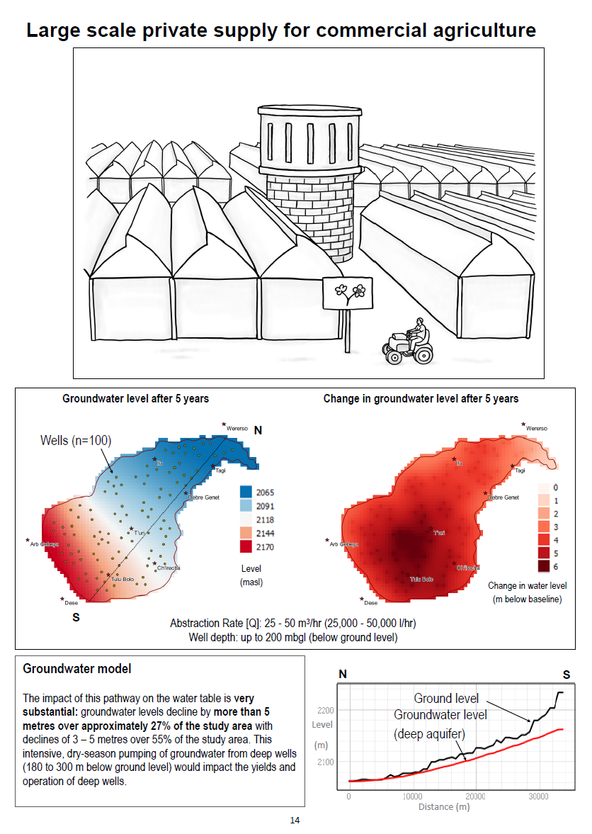
Pathway 6: Large-scale private supply for commercial agriculture
This pathway is evident in Ethiopia though not in Tanzania.
The impact of this pathway on the water table is substantial to very substantial. Groundwater levels fall 4 to 6 metres in approximately half of the study area in Tanzania and more than 5 metres over approximately 27 per cent of the study area in Ethiopia. This intensive pumping of groundwater would impact wetlands and would affect the yields and operation of shallow wells in Tanzania. In the dual layer aquifer modelled in Ethiopia, it would affect the functioning of deep wells.
Next Step: Analysing the Stress-Tested Pathways
In June and July 2019, there was a two multi-stakeholder workshops at which the groundwater development pathways were assessed using Multicriteria Mapping (MCM). It was hosted by colleagues from the Institute of Development Studies (IDS) and the ESRC STEPS Centre, the International Water Management Institute (IWMI) and University College London (UCL), in collaboration with partners at Sokoine University of Agriculture (SUA) and Addis Ababa University (AAU). This workshop will be the subject of another blog later in the year.
Read more
The Grofutures project focuses on:
Reducing uncertainty in the renewability and quantity of accessible groundwater to meet future demands for food, water and environmental services.
Promoting inclusion of poor people’s voices in decision-making processes on grountwater development pathways.
Intensified groundwater dependency as demand for food and water rises and variability in rainfall and river flow increases due to climate change.
Comments are closed.