by Ranit Chaterjee, Pankaj Joshi, Mahendra Bhanani, Mahesh Garva and Nobuhito Ohte
As part of the TAPESTRY project, we are working to understand the ecology of mangroves in Kachchh, on the western coast of India. Mangroves are an important part of the ecology of the district, providing shelter for animal life and shorelines, but are seen as threatened by a variety of influences, and there is much discussion about how best to direct conservation efforts.
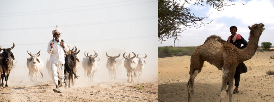
Mangroves are crucial in the livelihoods of pastoralists on the Kachchh coast. The area is home to the distinctive Kharai (swimming) camels: these graze on mangroves, and their herders sometimes cut mangroves for fodder. These practices and livelihoods go back many generations.
For conservation efforts to be directed in the right ways, it is important to know what effects camel grazing and cutting have on the mangroves and how pastoralists and camels interact with them. We also need to take account of the way that mangrove growth varies with the seasons, when we measure how much mangrove cover has changed over time.
This blog post describes how members of the TAPESTRY project have been working together with pastoralists to set up a research protocol that explores these questions.
About Kachchh
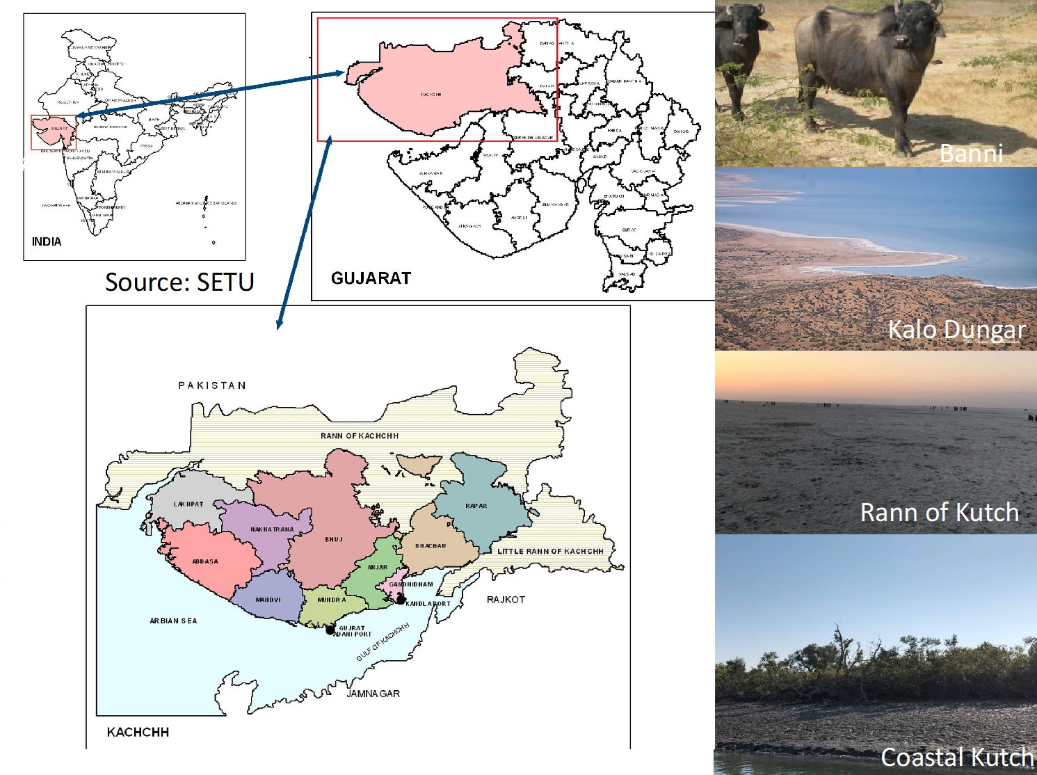
Kachchh (from the word for ‘tortoise’ in Sanskrit) is the largest district located in the Western part of India that borders Pakistan. Along with the famous white Rann (salt desert), Kachchh has been home to pastoralists for many generations.
The Maldharis or livestock-breeding tribes have been the torch-bearers of pastoralism in Kachchh. The word Maldhari comes by combining the words maal (animal stock) and dhari (owner/keeper). Among the Maldharis, the Unt (camel) Maldharis are marked by their socio-cultural connections with the camels.
Camel-rearing Maldharis are mainly represented by three communities: Rabari, Sama and Jat. These three groups are interdependent and have always been a close-knit community, linked by the camels they work with. Among the Jats, the Fakirani Jats mostly occupy the coastal region of Kachchh, and deal in the Kharai (swimming) breed of camels, a unique and endangered breed of camel known for their swimming ability and dependence on mangroves. (Other Kutchi camel breeds mainly feed on other vegetation that grows inland.)
Kachchh’s geography is varied. Its terrain includes the two Ranns (salty deserts), the coast with its mangroves, the hills, and the Banni plains (see image below). The census of 2011 showed a reverse trend of urbanization in Bhuj, and Gandhidham shows negative urbanization, while the Abdasa, Lakhpat and Nakhatrana areas have remained rural.
For the Maldhari pastoralists, the semi-arid landscape poses many challenges to daily life. These include water scarcity, scant vegetation, and fodder that varies with the seasons. On top of this, there are wider uncertainties from geophysical changes and climate change. Industrial development is also creating new pressures on the social and physical landscape of Kachchh.
The TAPESTRY project and the Unt Maldharis
Amid all of these uncertainties and challenges, the TAPESTRY project studies how sustainable transformations emerge and are coproduced amongst a wide range of actors who are dependent on natural resources – including the camel herders of Kachchh.
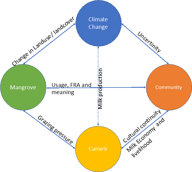
When applied to the life of Unt Maldharis, there are clear interdependences between them and their camels, mangroves and changes in the climate, as shown in the figure below.
To understand the specific struggles and transformations faced by these camel herders, we are working with the Kachchh Camel Breeders Association (KUUMS) of Kachchh. KUUMS is an association of Unt Maldharis who work towards conserving camels and their grazing resources, to increase the livelihood security of camel breeders, and to improve the health of the herds.
Establishing a participatory protocol for grazing pressure study
In order to establish a participatory study protocol for the TAPESTRY project, a meeting was organised in January 2020. The meeting of 12 people included some KUUMS members belonging to Mohadi, Bhangodi Vandh and other nearby settlements who keep Kharai camels; it also included TAPESTRY researchers and members of Sahjeevan (an NGO which works with KUUMS).
Step 1: Introduction
The TAPESTRY team introduced our project to the KUUMS members. We explained the framework above, and asked for their feedback on it. The KUUMS members said that the framework adequately represented the interlinkages between the four selected heads.
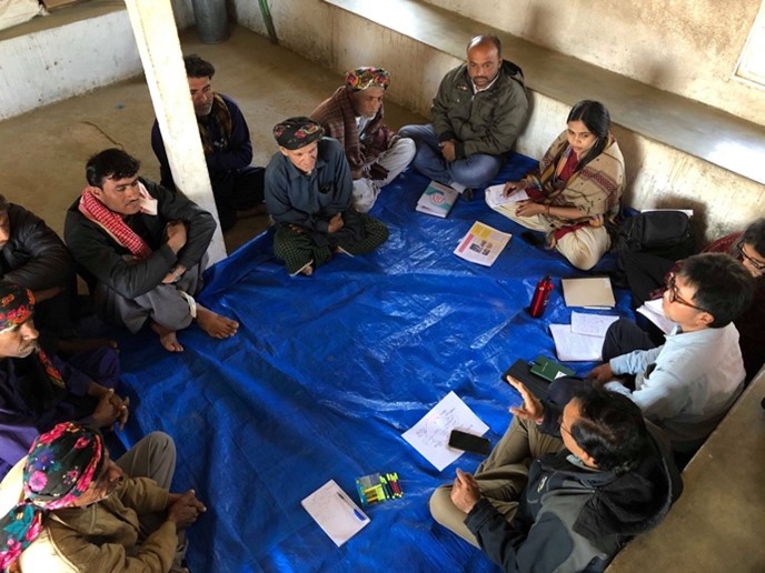
Step 2: Perceptions of pastoralists and selecting the research question
The TAPESTRY team asked the community if they thought that camel grazing leads to growth or degradation of the mangroves.
The KUUMS members said that, in their experience, the camel grazing helps in the growth of mangroves. Based on this, the central question of the study was decided as: “Does camel grazing lead to growth or depilation of mangroves?”
Step 3: Understanding the pressure on mangroves
The TAPESTRY team wanted to understand what types of pressures are exerted on the mangroves by humans and livestock. In response, the KUUMS members shared the following site-specific activities that affect mangroves.
- Grazing by camels
- Grazing by camels and buffalo
- Cutting by Maldharis for stall feeding of livestock
This information was useful for deciding the criteria for selecting research sites where these activities would take place. In addition, a site with the plant Prosopis juliflora (locally called Gando Bavar) and where mangrove generation was happening, was discussed.
Step 4: Seasonal variation of mangroves and the timeline for data collection
The discussion with the KUUMS members revealed the importance of four seasons (Summer, Monsoon, Post-Monsoon and Winter) on the grazing habits of camels.
In summer, monsoon and post-monsoon (March to October), the camels frequently graze on mangroves. In winter (November to February) the camels are less likely to graze on the mangroves. We discussed collecting data at four times (March-April, July-August, October-November and January-February) to see the changes in grazing patterns and their impact on the mangroves.
Step 5: Site selection
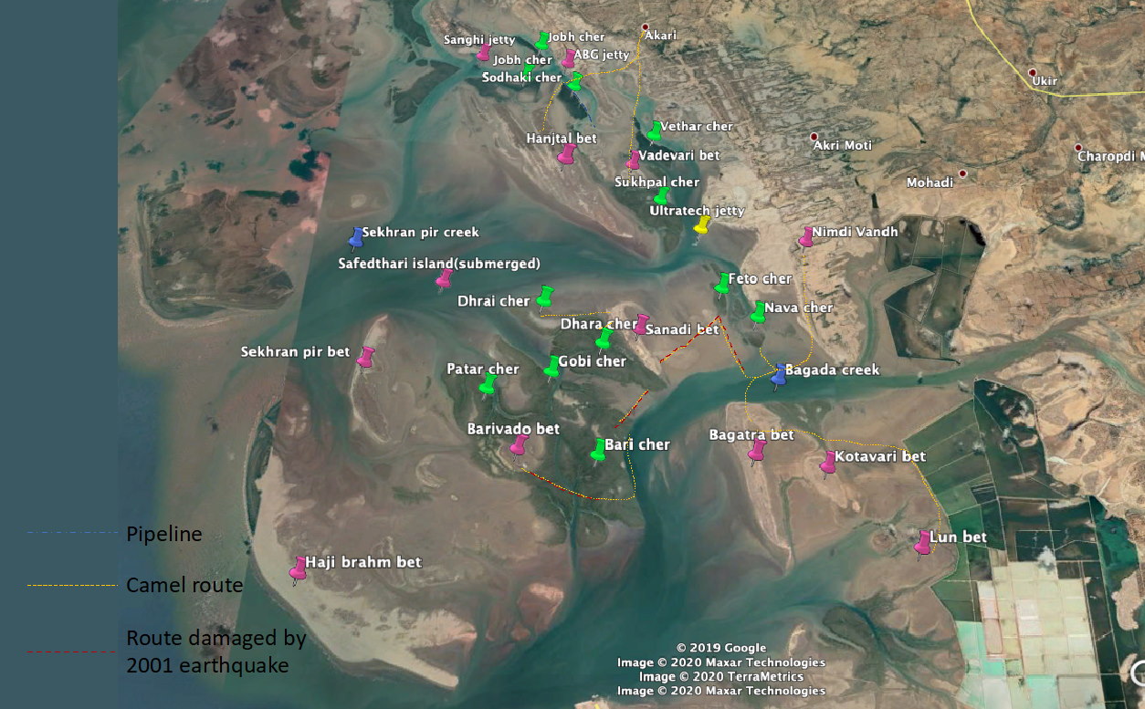
The next round of discussion was based on the site selection, according to the criteria set in the earlier discussions. The following sites were recommended by the KUUMS members to fulfil these criteria (‘Bet’ is a local name for a small island).
- Sandadi Bet: Summer and monsoon usage for 8 months: 250 camels from Mohadi, Nimdi and Vara Vandh
- Bado pir Bet: Summer usage for 4 months: 180 camels from Gunau, Bhangodi Vandh, Medi
- Bhagatram Bet: Monsoon and post-monsoon for 5-6 months: 200 camels from Mohadi and Nimdi
- Hanjtal Bet: Usage for 4 months if there is good rain: used by 180 camels, 2700-2800 buffalo and for cutting of mangroves. In case of bad rain, cutting by herders of Mohadi, Akri and Bhalavari.
We also selected a ‘control’ site which had no animal and human activities linked to mangroves. The KUUMS members suggested the fifth site as Sekhran Bet, which camels cannot reach because of the presence of a cement jetty.
Step 6: Establishing the site-specific protocols
In discussion with Sahjeevan, each site is divided into 4 quadrants. For each site it was decided that 3 controlled grids for each bet measuring 20x20m each will be selected, based on site observation.
This will mean we are studying 15 sites, and 3 additional grids will be selected to study the growth of new saplings. In total 18 grids will be selected. For each grid, we will be using a technique called systematic random sampling. We will also take photographs on each site before data collection for each season.
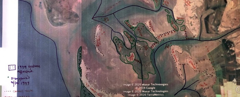
Step 7: Participatory site mapping
The next step was to identify each of these bets on the map and locate their coordinates. To do this, we conducted a participatory mapping exercise with a few selected members of KUUMS.
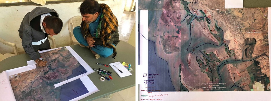
A Google map of the area was used a base map, and each of the bets and the mangroves were identified. The KUUMS members identified the routes which the camels take to each of the bets.
After this exercise was complete, the points were mapped online on Google Earth, and coordinates for each of the bets were identified.
Benefits of a participatory approach
Through this process, we aimed to create ownership of the research among people who are directly concerned with its outcomes. The process also helps to bring the local knowledge of camel herders on board in answering important questions about the ecologies of people, camels and mangroves.
The uncertainties faced by coastal camel herders come from many interlinked areas: development, industrial expansion, changing markets and environmental changes, among others. They are responding in different ways to these changes, while aiming to safeguard their livelihoods. A better understanding of the relationships between camels, people and mangroves will inform important debates over the future of the coasts of Kachchh, as pastoralists continue to seek sustainable futures for themselves and their camels.
About the authors
Ranit Chatterjee is Post-doctoral fellow at Kyoto University, Japan and a member of the TAPESTRY project.
Pankaj Joshi is Program Director, Biodiversity Conservation at Sahjeevan, a Kachchh-based organization that supports marginalised communities to revive their traditional ecological knowledge systems, conserve their ecological resources and strengthen their livelihoods. He is a member of the TAPESTRY project.
Mahendra Bhanani is Program Coordinator of the KUUMS Camel Project.
Mahesh Garva is Project Coordinator, Western Kachchh, KUUMS Camel Project.
Nubohito Ohte is Professor at Kyoto University, Japan and one of the Co-Principal Investigators of the TAPESTRY project.
Images: Ranit Chatterjee / TAPESTRY